rect
Riverton area and History
The Riverton Rock Riverton Area Kiwi Wilderness walk Make a booking

THE RIVERTON AREA AND HISTORY

Step back in time to 1905 in Riverton. This extract from the Cyclopedia of New Zealand sums it all up.....

RIVERTON was one of the first places in Southland to attract European settlers.  There are extensive areas of good land in the district, and the countryside has many pleasing features. Captain Howell was amongst the first to settle at Riverton situated on the estuary of the Aparima , at the point of its confluence with the Pourakino and forms a natural port.

rectrect
Local Maps Section
Riverton harbour 1902

On account of the rich lands along the Aparima and the fine pastoral country to the interior, Riverton soon became a place of some importance and a jetty was built for the convenience of shippers. 

Later on a railway was made from Riverton to Orepuki and to Nightcaps, via Thornbury; but in the earlier times the streets of Riverton were frequently crowded with bullock-drays laden with wool, grain and other produce, which was shipped from the port. 

The scenery 
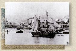
seen from South Riverton is very fine, and includes the waters of the estuary, with green hills relieved with small patches of pines and smiling homesteads, and, in the background, the timber-clad Longwood ranges, with the rugged ramparts of remoter mountains.  Riverton was incorporated as a borough in 1871.

During the summer season Riverton is popular as a resort with those in search of recreation or change of air.  Pleasant trips to various points up the Pourakino river may be taken by boat or oil launch; and there is a ideal picnic ground, where  the banks are clothed with lovely native vegetation, which meets in places overhead and forms a natural arbour.

Horse and steam tramways

From the bush-clad ridges above South Riverton the tourist sees Stewart Island,  the Bluff, Colac Bay and other bays, and the far-stretching South Pacific, with incoming and outgoing ships and steamers.

The climate is noted for its healthfulness, and the roads in the vicinity are very good for cycling during the season. 

A neighbouring Maori settlement, known as the Kaike, was originally the home of about 300 natives; and though this number has been considerably reduced, there are still in the district some well-to-do natives, who engage in fishing, seal-hunting, and mutton-birding in their seasons. 


The public offices of Riverton include the post office, magistrate's court and police station.  Gold has been found in the locality; there are quartz reefs on the Longwood ranges, and once, in recent years, a 30 ounce nugget was found in the district.

Besides another route by way of Wallacetown, there is a very fine road, to Invercargill along the Waimatuku beach, where there is hard sand when the tide is low, and a good horseman may enjoy one of the most exhilarating rides in the Southern Hemisphere.

Painting of a Maori tribe and wakas
Photos Courtesy of Wallace Early Settlers Museum, Riverton. Open 2pm - 4pm daily.

[ Queenstown Snow Cams | KiwiNewZ Home | New Zealand Native Birds
New Zealand News Zine | How the Kiwi Lost It's Wings
General New Zealand Information ]

Copyright Riverton Rock 1999. All rights reserved